Spatial Archive
Spatial Archive: Geo-spatial archives in DH can be defined as, ‘open-access DH projects that connect historical, narrative and or textual materials with geospatial coordinates for long-term preservation. The project then visualizes the materials to physical place/s using an interactive digital map which in turn serve as a geo-spatial archive of the materials that can facilitate further analysis’ (Spatial Hypertexts or Hypermaps: A Proposal for using Maps as Hypertexts in Geo-Spatial Archives; Justin and Menon, 2024).
Note: At present the archive has only two interactive points: 1. Kilvenmani Massacre and 2. Marichjhapi Massacre.
User Guide for the Spatial Archive
Methodology and Workflow of the Spatial Archive
The basemap of this archive makes use of Spatial Hypermaps – Read more here!
Workflow of the Spatial Archive:
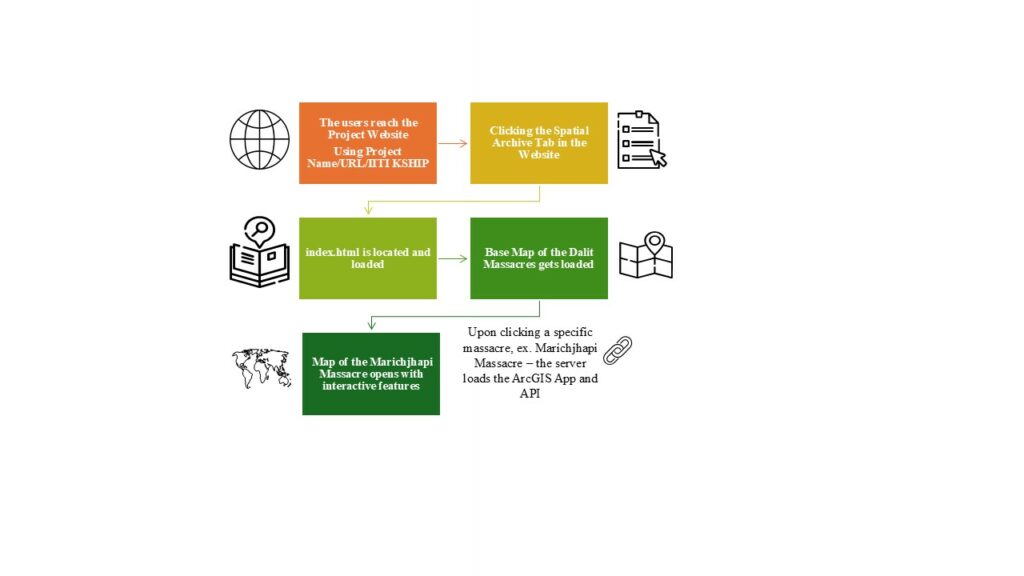
The workflow begins when the user initiates a request to access the project website either via direct search (using the name of the project or the URL https://mappingmassacres.iiti.ac.in/) or through IITI KSHIP portal. Upon reaching the project website the user can navigate to the page on the spatial archive. The server locates and loads the index.html that is embedded within the spatial archive page of the website. The users can then interact with the base map of the main Dalit massacres in India or access each massacre specific data of the female survivors. Clicking on the massacre points loads the ArcGIS Online Instant Apps created on the selected massacre including the ArcGIS API. The user can see the interactive map on the specific massacre with interactive layers (there is option to turn the layers on and off), search option as well as capture screenshots of the map at different scales/sizes.