What is Cartographies of Courage: Fictional Threads, Real Lives?
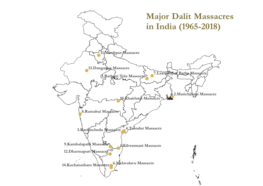
Cartographies of Courage: Fictional Threads, Real Lives is a project developed as part of the doctoral thesis of Ms. Jyothi Justin with the supervision of Prof. Nirmala Menon at the Digital Humanities and Publishing Studies Research Group (IIT Indore). It is the first project in India to offer theoretical, methodological, legal and pedagogical frameworks for understanding Dalit massacres. The aim of the project is to foreground the female narratives of selected Dalit massacres of independent India. At present the focus is on understanding the relations among space, caste and gender in Dalit massacres using feminist geocriticism and digital cartography. As a starting point, two massacres, 1. Kilvenmani Massacre, Tamil Nadu (1968) and 2. Marichjhapi Massacre, West Bengal (1979) are mapped in detail though we plan to expand to other massacres in future. The focus of the project is on the Dalit female survivors – both historical and fictional representation of the survivors. The project makes use of non-fictional texts, newspapers, letters, brochures and documentaries to identify the historical representations. Fictional texts and films are consulted to understand the fictional representations. This process further led to the creation of a spatial database of the survivors that facilitated their mapping using QGIS software. The archive is created using ArcGIS Online whereas the analysis is mostly done using ArcGIS Pro.
Methodology – Texts, Tools and Theory
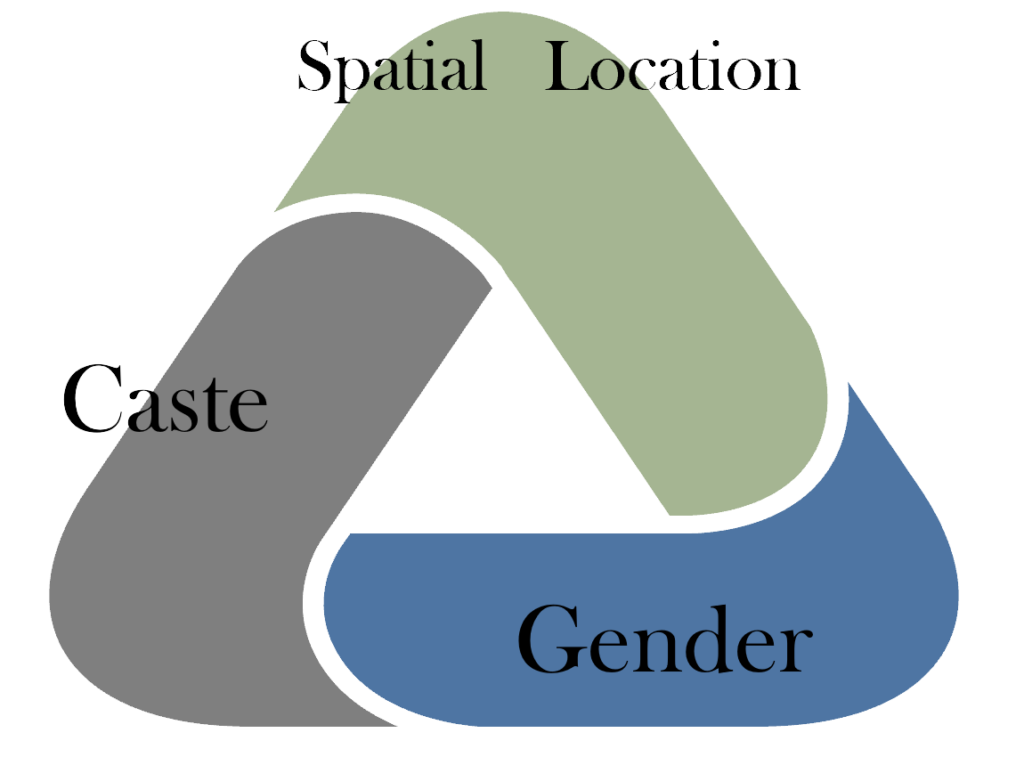
This study aims to foreground the female survivors of the selected Dalit massacres, by examining the relation between space, caste, and gender in massacres through the analysis of both the literary and non-literary narratives on the massacres.
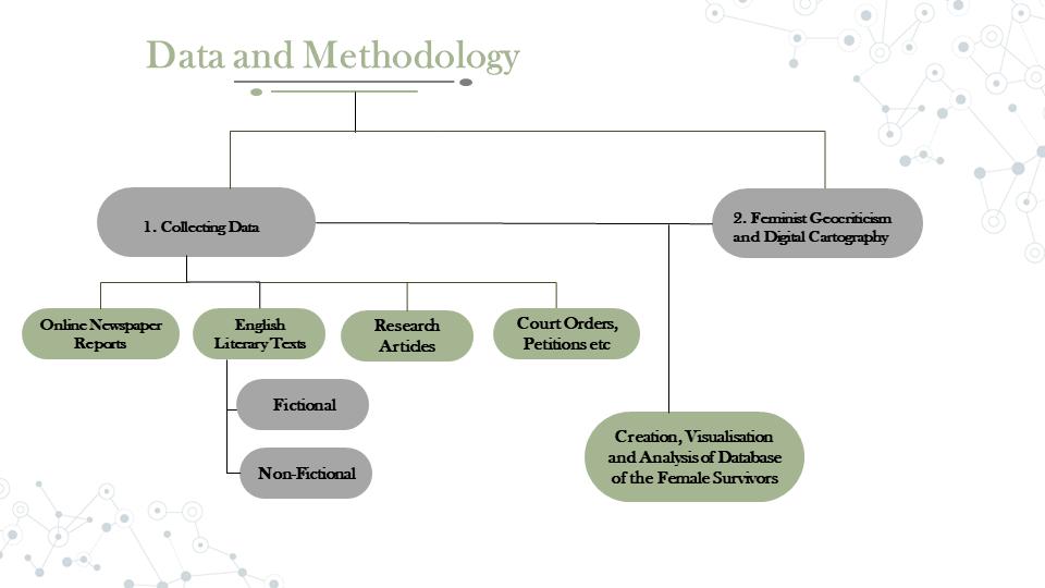
The first part of the project consisted of selecting a massacre and collecting materials and the nature of the materials assembled lead to the second part i.e., the methodology. The materials gathered as part of this study include, data compiled (manually scraped) from available online newspaper reports (the list in annexure 2), English literary texts (both fictional and non-fictional) and research articles resulting in the creation of a database of the survivors. Both textual and visual narratives along with the real survivor locations (and their narratives for the extended study) are considered for this study as ‘individual memory needs to be complemented by literature and film as an archive of memory in the public sphere – a public, collective, and non-statist memory’. Besides the database on the survivor, the location of the prominent writers on the massacre were also assembled, together with the analysis of the court orders, letters, petitions, etc., on the massacre. The diverse nature of the materials compiled as part of the project led to adoption of a methodology that is a combination of feminist geocriticism (theoretical analysis; qualitative) and digital cartography (practical and visual analysis; quantitative). This methodology was adopted to efficiently accommodate the materials collected and to utilize it to recognize the marginalized, invisible Dalit women of massacres.
Theoretical Framework: Geocriticism, Feminist Geocriticism and Digital Cartography – A Short Introduction
Geocritical approaches put forth by Bertrand Westphal (2007) and Robert Tally (2011) stresses the importance of space in literary research. Tally’s concept of geocriticism which is applied in this study, focuses on literary geography and the relation between the real and literary or imaginary spaces. It focuses on how the spatial critical theory which he termed “cartographics” (here digital cartography), could be used for the analytical criticism of literature i.e., geocriticism. Westphal’s (2007) geocriticism, on the other hand is, “a ‘geocentered’ approach to literature and cultural studies, which would allow a particular place to serve as the focal point for a variety of critical practices”. Westphal maintained that geocritics would begin by locating the place (geocentric) in an attempt to form an archive or corpus of literary and cultural representations of the place (Westphal, 2007), which is followed in this study as well. For Westphal (2007) geocriticism is a geo-centered rather than an ego-centered approach that is multifocal (focuses on different narratives) and polysensorial (includes sound, smell, taste and textures of a place) following a spatiotemporal scheme. However, both Westphal and Tally reiterates the idea that geocriticism is a developing theory that needs further exploration, examination, and expansion by researchers of spatial humanities. In short geocriticism “may be used to ask new questions, to read differently, to engage with other disciplinary methods, and to interpret the ways that we make sense of our own spaces, of our own mappings”.
The developing state of geocritical theory along with its interdisciplinarity allows it to be combined with feminism resulting in a new theory – feminist geocriticism. The nascent stage of feminist geocriticism itself, has led to different scholars interpreting and applying the theory in different ways. Amy D. Wells (2017), for instance, defines feminist geocriticism which she terms “geo-parler femme” as a theory “which analyses how geography can function as one of the codes used to create a female literary language”. Theda Wrede (2015), adds that feminist geocritics reads space as multiple, shifting and characterised by “difference”. Feminist geocriticism in the context of this study, however, pays attention to the historical/cultural/political location of Dalit women of selected Indian massacres and their representation in various narratives which will later be visualised and analysed using Digital Cartography.
Digital Cartography refers to the process of creating critical/analytical maps using digital technology and ranges from simple google maps to complicated mapping software such as GIS (QGIS/ArcGIS) etc. It helps to apply and visualise the geocritical approach. Digital maps created using GIS have the potential to fully utilise the multifocality and polysensorial techniques of geocriticism by combining the spatial data from different medium – literary texts, images, sounds, films, media reports etc., thereby suggesting new ways in reading and analysing space and place. It also becomes possible to identify gaps in spatial representations (for instance from a feminist perspective) and to compare and contrast the patterns of representation of the same space across different media and different time that may not be revealed using traditional Humanities research methods. Despite acting as visualisation tools, the digital maps themselves become a metadata upon which further spatio-temporal research becomes possible resulting in the expansion of the existing theories in Humanities or even in the creation of new theories. Digital cartography thereby fit into the conditions and characteristics of the Geocritical theoretical and methodological framework facilitating a multimodal and interdisciplinary spatial research.
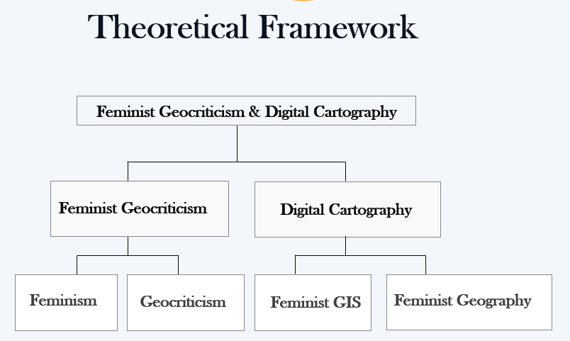
The use of digital maps together with feminist geocriticism enables researchers to visualise the patterns of locations and movements of Dalit women of the selected massacres on a single map (or space) and to analyse and theorise on the same. Geocriticism is therefore comparable to the ethnographic research method of ‘triangulation’ in which multiple data from various sources including “narrative and oral history as well as life experiences of sufferers have been used as a tool of research” and here the place serves as the central platform where the diverse data converge. Feminist Geocriticism and digital cartography intersect in several ways that facilitate a new methodology of using digital cartography in feminist geocriticism. For instance, both geocriticism and feminism are constantly emerging and expanding. Amy D. Wells (2014) draws the parallels between Geocriticism and Gender (feminist) studies based on their pluralistic character i.e., both geocriticism and feminist theories embrace multiplicity. Applying geocriticism to feminism and gender research unravels the importance of space in the reproduction and propagation of socio-cultural identity. Feminist theory is constantly expanding to include the intersectional experiences of women (identarian) and geocriticism is a multimodal and polysensorial spatial analytical method that can propose space as an intersectional category in addition to others like race, class, caste and gender. Therefore, combining both the theories result in a new method that sheds light on the interconnections between identity and space by analysing its representation in different medium.
Interested in knowing more about how feminist geocriticism and digital cartography intersects? – Read here!
Steps in Methodology
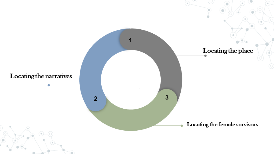
The methodology of the project consists of identifying the political, literary, and historical geographies (spaces) of the massacre to understand the intersections of the same. Differentiating the cultural shifts and postcolonial feminist identity formation (knowledge) also forms a part of the research question of the study. Locating the writer, reader and the text (power) within the same geography is the next part of the study. Following Westphal’s practice of geocriticism the study begins by locating the place (geocentric) to form an archive or corpus of literary and cultural representations of the place (Westphal, 2007). In this approach the multifaceted and dialectical dimensions of the massacre is focused thereby reducing the interference of the personal bias of authors in spatial interpretations (geocentrical rather than egocentrical approach).
The next process is a feminist geocritical pattern of identifying the women in the selected narratives. A database of the real and fictional women of the selected massacres is created which is to be utilized for the cartographic visualization as well. The database contains the real survivors of the massacres, identified from various sources like online newspaper reports, non-fictional works like oral history, research articles, etc., along with their geographic coordinates (location during the massacre or before it) and other relevant details. The fictional women of the database are identified from selected literary and visual narratives and the same is geocoded and utilized for mapping to understand the spaces where the real and the fictional women intersect. Identifying the real and fictional intersectional space will shed light on the similarities and differences in the portrayal of Dalit female experiences in various narratives.
Research Outcomes From the Project
In Media
“Digital Cartography and Feminist Geocriticism: A Case Study of Marichjhapi Massacre” at UNED-LINHD TNA Mini Conference as part of CLS INFRA TNA Fellowship. On 24 April, 2024, 10.30-11.00am CEST
“Using Digital Cartography and Feminist Geocriticism in Literature: Locating the Women of Kilvenmani Massacre (1968)” at UNED-LINHD Spring 2024 Seminar Series as an Exchange researcher of the CLS INFRA project of the European infrastructure DARIAH.EU. On 17 April 2024.
“Digital Cartography and Feminist Geocriticism: A Case Study of the Marichjhapi Massacre” at HASTAC Scholars’ Digital Friday: A Tapestry of Digital Narratives on 12 April, 2024
“Digital Cartography and Feminist Geocriticism in Literary Studies – A Proposal” at the 5th ACM SIGSPATIAL International Workshop on Geospatial Humanities held in conjunction with ACM SIGSPATIAL 2021 in Beijing, China (Virtual via zoom). Also ACCEPTED for publication in Conference Proceedings of ACM Digital Library, 02 November, 2021.
Design Choices, Tools, Plugins. . .
This project uses the colour blue (#40739d) as it is widely used to symbolise Dalit identity, drawing on its association with resistance, dignity, and the legacy of Dr. B.R. Ambedkar, who championed the rights of marginalised communities in India.
Font Used – Gotu
Colour Codes
Blue – #40739d
Copper – #B87333
WordPress Theme – Extendable
Plugins Used
MapGeo – Interactive GeoMaps
Page Contents
- What is Cartographies of Courage: Fictional Threads, Real Lives?
- Methodology – Texts, Tools and Theory
- Theoretical Framework: Geocriticism, Feminist Geocriticism and Digital Cartography – A Short Introduction
- Steps in Methodology
- Research Outcomes From the Project
- In Media
- Design Choices, Tools, Plugins. . .